I have downloaded the shapefile for European NUTS region fro here.
In particular I have downloaded the 1:1 Million SHP file for NUTS 2021 from here.
I have opened them using QGIS.
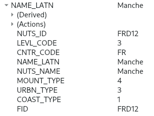
In each region there are 3 categorical variables, named "MOUNT_TYPE", "URBN_TYPE", and "COAST_TYPE", as can be seen in this example from Mance:
What does the value of that categorical variables represent?
There is a "metadata.pdf" file together with the shapefile that doesn't explain them. Also the online reference in that PDF file doesn't explain them.
I googled for them but could not find anything.
